Chet from Garmin is teasing us about "Bobcat": code name for a Garmin software product for the Macintosh to be released at San Francisco MacWorld next week.
Two years ago Garmin promised to move its software to Mac OS X "by the end of 2006", but it has been rather slow. There have been some recent releases from Garmin to support using Garmin GPS devices on the Macintosh, though: POI Loader for Mac, MapInstall for Mac, and MapConverter for Windows. (Thanks, MacOS X Hints!)
10 January 2008

03 December 2007
01 December 2007
GPS-enabled cameras?
All of the complicated work that needs to be done now to geocode (or geotag) photographs could be a thing of the past if founder of SiRF chip company Kanwar Chadha is right. According to Stephen Shankland, blogging on Underexposed at c|net News.com, Chadha is predicting cameras with GPS capability will start hitting the market next year in quantity. Shankland's article covers a range of issues with knowing where photos were taken, particularly if the photos are shared through social networking sites like MySpace, Flickr and SmugMug. While there are privacy and personal security issues with sharing any information about yourself, family and friends, if managed properly adding location data is an opportunity to explore user-generated photographs in new ways.
14 November 2007
More on Photosynth: Wired Science video
The more I see of Photosynth, the more I want to see something like it on the Macintosh, but done better using Core Animation in Leopard.
03 November 2007
Live Maps 3D
Microsoft has integrated Photosynth in Live Maps Virtual Earth 3D (technology preview). No audio in the video, apparently.
Got this from vincenthome.
Why this in a Macintosh blog on GPS? Hoping to see this sort of technology available on the Mac (Virtual Earth 3D requires ActiveX controls)
Got this from vincenthome.
Why this in a Macintosh blog on GPS? Hoping to see this sort of technology available on the Mac (Virtual Earth 3D requires ActiveX controls)
02 November 2007
Using Panoramio
I've been experimenting with Panoramio to simplify serving up geocoded photographs: have a look at a track and the photos from a recent walk in the Warrumbungle National Park. Download the .kmz file and open it in Google Earth. As you change the view on the map, only the photos available in the area covered are included in the list.
29 October 2007
Cool new Leopard Preview feature
I've just come back from a couple of weeks away and while geocoding the photos using the usual tools and now Geotagger from Craig Stanton (Craig also developed the iPhotoToGoogleEarth plugin for iPhoto 6 that I use), I discovered that Preview in Leopard on the Macintosh has a cool new feature when you use it to look at geocoded photographs.
Try this at home:
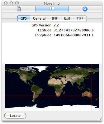
You should see the location data for the photo and the photo's location on the map. Click the Locate button to see the location of the photo in Google Maps.
Try this at home:
- Open a geocoded photo in Preview v4. If you don't have a geocoded photo, here's one of the Warrumbungle National Park from Siding Springs [warning: 4.7MB file] that I prepared earlier. Save it to disk before opening in.
- Choose Inspector from the Tools menu.
- Click the 'i' tab in the Inspector window at the top in the centre.
- Click the GPS tab in the second line of tabs in the Inspector window.

You should see the location data for the photo and the photo's location on the map. Click the Locate button to see the location of the photo in Google Maps.
Subscribe to:
Posts (Atom)

