14 August 2008
Manual geotagging in Aperture
Maperture is a plug-in for Aperture from Übermind that allows you to add latitude and longitude metadata manually to Aperture photos from within the application itself. Works with Nikon NEF RAW images and jpegs, but not TIFFs. It will preserve any existing geotags in the images. Best of all is the price: it's free!
19 May 2008
Recent geocoding examples
I have been busy, really! As well as working on a Carrick project with the University of Canberra, I've been accepted into a PhD program with Photography and Media Arts at the School of Art at the Australian National University. My Proposal and Journal are on my .Mac pages, so visit those for the details of my program and activities. I've also posted a few recent examples of the integration of geocoded photographs on Panoramio with Google Maps and Google Earth on Yet Another Blog I have.
 Loch Garra, Davidson Whaling Station historic site, Twofold Bay
Loch Garra, Davidson Whaling Station historic site, Twofold Bay01 April 2008
Google and Garmin add Send to GPS option
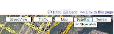
In the US at least, you can now send the location of businesses that you find on Google Maps to your Garmin GPS. It works through Firefox with my Garmin nüvi 760: first of all find the business you want in Google Maps (it doesn't work in Australia, but I've made it work for US businesses), then click the Send link towards the top-right of the Maps window, between Print and Link to this page (with the icon of the envelope to the left).
In the 'window' that appears, click the GPS link on the left. If the GPS link isn't there, the location can't be transferred to your GPS.
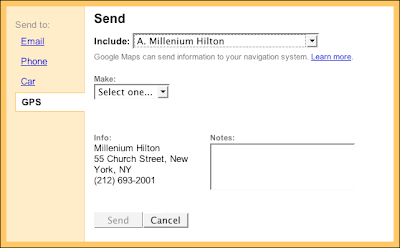
Choose the location you want to transfer from the Include: popup, then choose Garmin from the Make: popup. Click the Send button. This should take you to the Garmin website. The first time you try it, you will need to install the Garmin Communicator plug-in. This works with Firefox for me, but not Safari. Download and install the plug-in, then follow the instructions. Be careful the installer doesn't take you back to Safari after the installation, make sure it's Firefox.
How about other locations, apart from businesses, Google?
UPDATE 7 April 2008: You CAN transfer the locations you find to the GPS, not just businesses. And it works in Australia, too. Either I missed it originally or something has changed in the past week. So just execute a search for an address, and when it's found, click the Send link (with the envelope icon), and choose the GPS link.

In the 'window' that appears, click the GPS link on the left. If the GPS link isn't there, the location can't be transferred to your GPS.
Choose the location you want to transfer from the Include: popup, then choose Garmin from the Make: popup. Click the Send button. This should take you to the Garmin website. The first time you try it, you will need to install the Garmin Communicator plug-in. This works with Firefox for me, but not Safari. Download and install the plug-in, then follow the instructions. Be careful the installer doesn't take you back to Safari after the installation, make sure it's Firefox.
How about other locations, apart from businesses, Google?
UPDATE 7 April 2008: You CAN transfer the locations you find to the GPS, not just businesses. And it works in Australia, too. Either I missed it originally or something has changed in the past week. So just execute a search for an address, and when it's found, click the Send link (with the envelope icon), and choose the GPS link.
16 January 2008
Garmin inches towards Mac OS X support
Two years after first announcing that Garmin would support the Macintosh within the year, more software (still in beta) was announced at San Francisco MacWorld this week.
Codednamed Bobcat, the software "allows you to transfer waypoints, tracks, and routes between your Mac and Garmin device and manage your data using your Garmin maps". Garmin maps still aren't available in Macintosh format (you have to convert your Garmin PC maps with MapConverter for Windows, then use MapManager on the Macintosh to make them accessible to Bobcat).
If I have a few spare moments I'll fire it all up and see how it goes. Will only work with Garmin USB devices.
10 January 2008
Increasing Garmin support for the Macintosh
Chet from Garmin is teasing us about "Bobcat": code name for a Garmin software product for the Macintosh to be released at San Francisco MacWorld next week.
Two years ago Garmin promised to move its software to Mac OS X "by the end of 2006", but it has been rather slow. There have been some recent releases from Garmin to support using Garmin GPS devices on the Macintosh, though: POI Loader for Mac, MapInstall for Mac, and MapConverter for Windows. (Thanks, MacOS X Hints!)
Two years ago Garmin promised to move its software to Mac OS X "by the end of 2006", but it has been rather slow. There have been some recent releases from Garmin to support using Garmin GPS devices on the Macintosh, though: POI Loader for Mac, MapInstall for Mac, and MapConverter for Windows. (Thanks, MacOS X Hints!)
Subscribe to:
Posts (Atom)
