Last weekend we wanted to visit a local winery (Yarrh, pronounced
yaar) to try their Sangiovese. From their
website map I could see where to go, but thought it would be a good exercise to see if I could transfer the data from
Google Maps to my Garmin GPS to guide us there.
Turns out it's quite simple with
My Maps (make sure you are logged in to Google: the link takes to you to maps.google.com.au), together with
TakItWithMe - Google™ My Maps Converter Beta, and
MacGPS Pro.
 Google My Maps line tool
 Once logged in to
My Maps, create a new map and use the line tool to draw a line from the beginning to the end of the route.
Click at each intersection along the route to draw the route. Double click at the destination to finish the route.
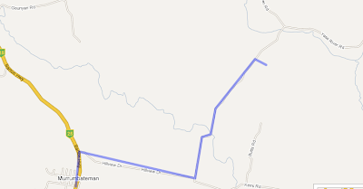
Save the map.
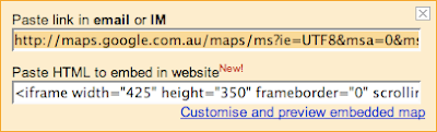
 Graphic of the Link to this page link
Click the Link to this page link, and copy the data in the text field under Paste link in
email or
IM heading.
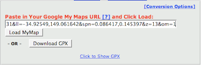
Go to the
TakItWithMe website, and paste the data you copied into the
Paste in Your Google My Maps URL text field. Click the Download GPX button.
You can then transfer the GPX file to your GPS device, for example using MacGPS Pro. Open MacGPS Pro, open the gpx file you just created, select the route using the Route tool (select the route tool; click one of the waypoints on the route) and transfer the route file to the GPS using the transfer tool.
Another way to do it would be to create Placemarks (rather than a line) in My Maps, then transfer these to MacGPS Pro via a GPX file using this same method. Create a new route in MacGPS Pro between the Placemarks (which become Waypoints in MacGPS Pro). If you have named the Placemarks meaningfully in My Maps you should get a route with meaningful names for Waypoints on the GPS.


