29 September 2009

Great way to sync the camera and GPS times

Now that I use Maperture Pro to geocode my images inside Aperture, getting the camera time accurate is even more important. Offsetting the time is possible in Maperture Pro, but if the camera time is accurate it's much easier to geocode the images and cuts out a potentially problematic step.

I have the display on my computer set to show seconds as well as hours and minutes. In the Date & Time System Preference it's set to sync the date and time automatically, so it should be accurate within a few seconds of the satellite time on the GPS. Just before I go out shooting I use the clock on the computer screen to set the camera, then shoot a shot of the clock to confirm the correspondence.

If you download the image below and check the Exif data, the date and time of the original image match the time captured in the image.

05 September 2009

VicMap 1:25k topo maps and MacGPS Pro

The 1:25k topo maps for the whole of Victoria are now available through MapTrax. There is a package of sample files available for download to check whether the VicMap maps will work with your application: they are designed to work with Ozi Explorer on the PC, but if you want to run them on the Macintosh you will have to use your own application since Ozi Explorer doesn't run on the Mac. I downloaded the sample package but the .ecw file in the package would not import into MacGPS Pro with the coordinates set.

I wrote to James Associates and Larry James was quick to respond with the answer: when you try to import an .ecw file, MacGPS Pro looks for a .map file in the same folder with the same name if it can't find the georeferencing information in the file itself.

Unfortunately the .map files are named differently from the .ecw files they relate to, but the fix is simple: rename the .map file with the same name as the .ecw file (or vice versa), just keep the original extensions, .ecw or .map. Now when you import the .ecw file it finds the .map georeference file and sets the coordinates automatically.

So I bought the set. 846 maps. I copied the entire ECW VicGrid folder across from DVD 1 to the hard drive, took the "georef25k_" off the beginning of all the filenames using the freeware Name Mangler, then went through all the files manually and renamed the .ecw files with the same name as the .map files: I couldn't think of an easy programmatic way of doing it. So now I just find the .ecw file of the map I need and import it into MacGPS Pro.

To find the map I want, I've converted the mapping_program_25kindex.pdf file into several PICT files using Graphic Converter, then manually added the coordinates (using the .ecw files to find coordinates). I've assumed the projection is Transverse Mercator and the geodetic datum is GDA94, which isn't exactly true, but it gives enough of an indication of which topo maps to look on for a waypoint created on Google Earth or in MacGPS Pro.

05 July 2009

Overlaying a topographic map on Google Earth

Overlaying a topographic map on Google Earth with the Terrain layer on adds significantly to the information available in the GE view. It would be much simpler if Google Earth supported the .ecw file format: ecw files of the NSW Raster Topographic Maps contain the location data for the map, so the maps could be located automatically on import.

As it is the locations have to be done manually.
  1. Convert .ecw map to an image file format that Google Earth understands (eg. TIFF, JPG, PNG).
  2. Cut the map up into tiles in PhotoShop, to the required tile size. Note that a complete topo map will pixelate in GE so make it about one quarter of a 1:25k map per tile. Trim along grid lines to make the following steps easier.
  3. Import the original .ecw file in MacGPS Pro.
  4. Use MacGPS Pro to find the latitude and longitude of the corners of each tile from the trimmed map, in decimal degree format.
  5. In Google Earth, Add an Image Overlay, and link it to the map tile.
  6. Open the Location tab in the Layer object Get Info window, and click the Convert to LatLonQuad button.
  7. Click OK to close the Get Info window, then open it again by right-clicking the Overlay in the My Places pane (you have to do this, at least on the Mac, to get the display to change to the four tuple pane).
  8. Click the Location tab. There should now be four coordinate tuples in the window.
  9. Replace the values with the co-ordinates found in Step 4 above. The First Corner is the bottom left, Second Corner is bottom right, and so on around the tile anti-clockwise.
  10. Click OK to close the Get Info window, and providing you have recorded and entered the values for the corners accurately the tile should now be in place.

Set the transparency of the overlay to 50% or less to get the effect in the image above.

Ensure the Terrain layer is active to see the map draped over the terrain.

The documentation for LatLonQuad details the format of the kml file required to display the map tile properly.

14 August 2008

Manual geotagging in Aperture

Maperture is a plug-in for Aperture from Übermind that allows you to add latitude and longitude metadata manually to Aperture photos from within the application itself. Works with Nikon NEF RAW images and jpegs, but not TIFFs. It will preserve any existing geotags in the images. Best of all is the price: it's free!

19 May 2008

Recent geocoding examples

I have been busy, really! As well as working on a Carrick project with the University of Canberra, I've been accepted into a PhD program with Photography and Media Arts at the School of Art at the Australian National University. My Proposal and Journal are on my .Mac pages, so visit those for the details of my program and activities. I've also posted a few recent examples of the integration of geocoded photographs on Panoramio with Google Maps and Google Earth on Yet Another Blog I have.

Loch Garra, Davidson Whaling Station historic site, Twofold Bay

01 April 2008

Google and Garmin add Send to GPS option

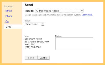
In the US at least, you can now send the location of businesses that you find on Google Maps to your Garmin GPS. It works through Firefox with my Garmin nüvi 760: first of all find the business you want in Google Maps (it doesn't work in Australia, but I've made it work for US businesses), then click the Send link towards the top-right of the Maps window, between Print and Link to this page (with the icon of the envelope to the left).


In the 'window' that appears, click the GPS link on the left. If the GPS link isn't there, the location can't be transferred to your GPS.


Choose the location you want to transfer from the Include: popup, then choose Garmin from the Make: popup. Click the Send button. This should take you to the Garmin website. The first time you try it, you will need to install the Garmin Communicator plug-in. This works with Firefox for me, but not Safari. Download and install the plug-in, then follow the instructions. Be careful the installer doesn't take you back to Safari after the installation, make sure it's Firefox.

How about other locations, apart from businesses, Google?

UPDATE 7 April 2008: You CAN transfer the locations you find to the GPS, not just businesses. And it works in Australia, too. Either I missed it originally or something has changed in the past week. So just execute a search for an address, and when it's found, click the Send link (with the envelope icon), and choose the GPS link.

16 January 2008

Garmin inches towards Mac OS X support

Two years after first announcing that Garmin would support the Macintosh within the year, more software (still in beta) was announced at San Francisco MacWorld this week.

Codednamed Bobcat, the software "allows you to transfer waypoints, tracks, and routes between your Mac and Garmin device and manage your data using your Garmin maps". Garmin maps still aren't available in Macintosh format (you have to convert your Garmin PC maps with MapConverter for Windows, then use MapManager on the Macintosh to make them accessible to Bobcat).

If I have a few spare moments I'll fire it all up and see how it goes. Will only work with Garmin USB devices.

10 January 2008

Increasing Garmin support for the Macintosh

Chet from Garmin is teasing us about "Bobcat": code name for a Garmin software product for the Macintosh to be released at San Francisco MacWorld next week.

Two years ago Garmin promised to move its software to Mac OS X "by the end of 2006", but it has been rather slow. There have been some recent releases from Garmin to support using Garmin GPS devices on the Macintosh, though: POI Loader for Mac, MapInstall for Mac, and MapConverter for Windows. (Thanks, MacOS X Hints!)

03 December 2007

Another Photosynth video

A more detailed video covering Photosynth from Microsoft Live Labs:


01 December 2007

GPS-enabled cameras?

All of the complicated work that needs to be done now to geocode (or geotag) photographs could be a thing of the past if founder of SiRF chip company Kanwar Chadha is right. According to Stephen Shankland, blogging on Underexposed at c|net News.com, Chadha is predicting cameras with GPS capability will start hitting the market next year in quantity. Shankland's article covers a range of issues with knowing where photos were taken, particularly if the photos are shared through social networking sites like MySpace, Flickr and SmugMug. While there are privacy and personal security issues with sharing any information about yourself, family and friends, if managed properly adding location data is an opportunity to explore user-generated photographs in new ways.

14 November 2007

More on Photosynth: Wired Science video

The more I see of Photosynth, the more I want to see something like it on the Macintosh, but done better using Core Animation in Leopard.

03 November 2007

Live Maps 3D

Microsoft has integrated Photosynth in Live Maps Virtual Earth 3D (technology preview). No audio in the video, apparently.


Got this from vincenthome.

Why this in a Macintosh blog on GPS? Hoping to see this sort of technology available on the Mac (Virtual Earth 3D requires ActiveX controls)

02 November 2007

Using Panoramio

I've been experimenting with Panoramio to simplify serving up geocoded photographs: have a look at a track and the photos from a recent walk in the Warrumbungle National Park. Download the .kmz file and open it in Google Earth. As you change the view on the map, only the photos available in the area covered are included in the list.

29 October 2007

Cool new Leopard Preview feature

I've just come back from a couple of weeks away and while geocoding the photos using the usual tools and now Geotagger from Craig Stanton (Craig also developed the iPhotoToGoogleEarth plugin for iPhoto 6 that I use), I discovered that Preview in Leopard on the Macintosh has a cool new feature when you use it to look at geocoded photographs.

Try this at home:
  1. Open a geocoded photo in Preview v4. If you don't have a geocoded photo, here's one of the Warrumbungle National Park from Siding Springs [warning: 4.7MB file] that I prepared earlier. Save it to disk before opening in.
  2. Choose Inspector from the Tools menu.
  3. Click the 'i' tab in the Inspector window at the top in the centre.
  4. Click the GPS tab in the second line of tabs in the Inspector window.


You should see the location data for the photo and the photo's location on the map. Click the Locate button to see the location of the photo in Google Maps.

25 September 2007

Links to Macintosh GPS tools

These are the links to the tools I used in my GPS for the Mac presentation at the Apple University Consortium Conference at the Royal Pines Resort, Gold Coast, on 24 September 2007.

  1. Graphic Converter
  2. MacGPS Pro
  3. GPSBabel +
  4. PhotoGPSEditor
  5. iPhoto + iPhotoToGoogleEarth
  6. Google Earth
  7. StuffitExpander
  8. BBEdit
  9. Safari

Here's the GPS Mac presentation in Acrobat format (.pdf, 668kB), and the paper in Word (.doc, 5.6MB).

16 September 2007

Canberra Nature Parks maps

Here in the ACT the local government has published a series of Acrobat maps of the the local Nature Parks. Download the maps and import them into MacGPS Pro (it will open the PDF file directly). The ones I've tried work with the Geodetic Datum set to GDA94; Map Projection to Transverse Mercator; and UTM Zone to 55H. Calibrate the map using Google Earth (see Calibrating NATMAP Raster Premium Maps for the technique). You should independently verify the calibration before relying on the maps for navigation.

15 September 2007

Google Maps to your GPS via MacGPS Pro

Last weekend we wanted to visit a local winery (Yarrh, pronounced yaar) to try their Sangiovese. From their website map I could see where to go, but thought it would be a good exercise to see if I could transfer the data from Google Maps to my Garmin GPS to guide us there.

Turns out it's quite simple with My Maps (make sure you are logged in to Google: the link takes to you to maps.google.com.au), together with TakItWithMe - Google™ My Maps Converter Beta, and MacGPS Pro.
Google My Maps line tool

Once logged in to My Maps, create a new map and use the line tool to draw a line from the beginning to the end of the route. 

Click at each intersection along the route to draw the route. Double click at the destination to finish the route.
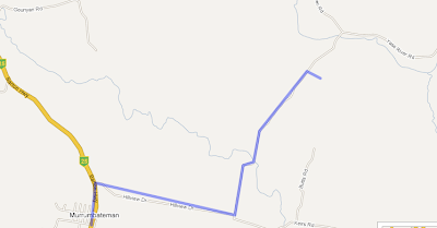

Save the map.

Graphic of the Link to this page link

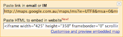
Click the Link to this page link, and copy the data in the text field under Paste link in email or IM heading.

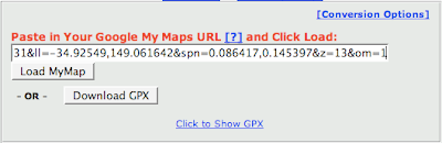
Go to the TakItWithMe website, and paste the data you copied into the Paste in Your Google My Maps URL text field. Click the Download GPX button.

You can then transfer the GPX file to your GPS device, for example using MacGPS Pro. Open MacGPS Pro, open the gpx file you just created, select the route using the Route tool (select the route tool; click one of the waypoints on the route) and transfer the route file to the GPS using the transfer tool.

Another way to do it would be to create Placemarks (rather than a line) in My Maps, then transfer these to MacGPS Pro via a GPX file using this same method. Create a new route in MacGPS Pro between the Placemarks (which become Waypoints in MacGPS Pro). If you have named the Placemarks meaningfully in My Maps you should get a route with meaningful names for Waypoints on the GPS.

Help with My Maps

Google has added a couple of movies to help you with mashups using other people's data or adding your own content to Google Maps My Maps. Here's a featured example of Bo Majewski's personal experiences of Sydney using My Maps.

Google Australian Electoral guide

Not strictly speaking a Macintosh GPS subject, but Google has launched a site on the forthcoming Australian Federal election that includes a find your electorate feature using Google Maps My Maps feature (warning: doesn't work in Safari). You will need to log in to Google to see the option under 'Featured content' on the right ('Australian 2007 Election').

If you have Google Earth you can also download a kmz file to add a map layer for the electorates there.

05 September 2007

Mercedes (or BMW) for my next car?

At least for driving (if you are in the US and want to buy a new Mercedes) you can now transfer directions from Yahoo! Maps or Google Maps to you car's GPS: it's called Search & Send. BMW has been working with Google to do a similar thing for BMW as well. Watch the videos for Search & Send: it works through a browser so the platform doesn't come into it.